Where was this Mopar Brochure/Ad Photo shot?

Last one from me for a while


Where is this 1952 Chrysler Ghia d’Elegance parked?

View attachment 599552

1. What northeastern US city and state is the Ghia parked?
2. Approximately where (a specific location and approxiimately where in that location) is it parked?
3. What was (are the time it opened) the signficance of the "Modern Marvel" in the background?

PM if you want a confirmation of your answers.

Answer posted Friday (three days from now).
Image176u5678.jpg


Alan
 
#440 .

1.
Fort Lee, NJ, 2. Ghia is in Ross Dock Picnic Area on the Hudson, and 3. the George Washington Bridge in the background (I-95 uses the GW),

Seventy five years old now, still one of the busiest suspension bridges in the world and the ONLY 14 lane (2 lanes added in 1946, and second level added six lanes in 1962) suspension bridge in the world. Truly a "Modern Marvel" (45 minute vid if interested).

When it opened in 1931, it was the only six-lane suspension bridge in the world, and for a time had the longest center-span of any suspension bridge in the world as well (took the title from the Ambassador bridge between Detroit and Windsor Ontario.

One reported solver in #441, with an excellent Google Earth pic of the exact spot as you can see on the right.

1685643253735.png


Note the GW bridge designer was responsible for almost all the major NYC bridges and tunnels (e.g., Verrazzano-Narrows, Lincoln Tunnel, etc.,).

Othmar Ammann
800px-Othmarbust.jpg


As close as I got with Google Maps' user photo from Ross Dock picnic area.

Car (red box) would have been out there in the clearing. View is southerly down the Hudson, NYC skyline (downtown Manhattan in the distant background) so that means the New Jersey GW tower is the one in the near background.
FLW 99G.png


Fort Lee looking northeasterly across the Hudson toward upper Manhattan (tho that may be the Bronx that far north) and points east.
1685643908323.jpeg


In context via Google Maps.
FLW 9KC.png
FLW 9KC.png
1685642395377.png
1685204430932-png.png
 
Last edited:
#440 .

1.
Fort Lee, NJ, 2. Ghia is in Ross Dock Picnic Area on the Hudson, and 3. the George Washington Bridge in the background (I-95 uses the GW),

Seventy five years old now, still one of the busiest suspension bridges in the world and the ONLY 14 lane (2 lanes added in 1946, and second level added six lanes in 1962) suspension bridge in the world. Truly a "Modern Marvel" (45 minute vid if interested).

When it opened in 1931, it was the only six-lane susptension bridge in the world, and for a time had the longest center-span of any suspension bridge in the world (took the title from the Ambassasor bridge between Detroit and Windsor Ontario.

One reported solver in #441, with an excellent Google Earth pic of the exact spot as you can see.

View attachment 599820


Note the GW bridge designer was responsible for almost all the major NYC bridges and tunnels. Othmar Ammann
View attachment 599824

As close as I got with Google Maps' photo from Ross Dock picnic area.

Car (red box) would have been out there in the clearing. View is southerly down the Hudson, NYC skyline (downtown Manhattan in the distant baclground) so that means the Jersey GW tower is the one in the near background.
View attachment 599804

Fort Lee looking northeasterly across the Hudson toward upper Manhattan and points east.
View attachment 599823

In context via Google Maps.
View attachment 599809View attachment 599810View attachment 599811View attachment 599825
Another great post for this game. Wish I would have had the time this week to play.
 
One last series of this game for 2023.

This one is NOT like naming the girls --- you can use any tool, technique, whatever you want to find the answer. No such thing a "cheating", because "googliing" the pic/clues is sometimes the ONLY way to "win".

Three specific answers are also the goal.

As such, unless you have BEEN to these places, these games are HARD, if one's internet skills/time to sleuth are limited. They also tend to only attract the same group of about 10 players.

Every solver gets a "dude" truck recognition, so its kinda a fun competition in that regard. Please consider letting the game run until the end, but please post when you have the three questions answered.

We'll see if have any players left.


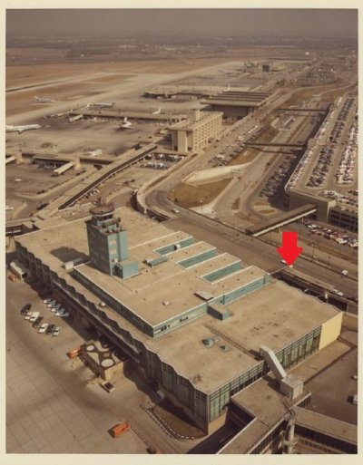
Where were these 1958 Furys standing?

Three correct answers needed. with a bonus answer.

1. What U.S. city in the Great Lakes region is this?
2. Exact location is NOT in that city, but was NAMED for that city?
3. The exact building, an architecturally distinctive (the glass was "green"), modern structure when it opened in 1957, closed in 2008, and was TORN DOWN in 2019.

EXTRA BONUS .. This building, was named after a specific person - what was the name?

PM me if you wanna confirm a three part guess.

Answer this coming Sunday if no one gets it.

Sport fury 8.jpg
 
Last edited:
Dang That Was hard, but I found it it, will fill in the blanks later.


Alan
This is a good one sir. I am getting stumped!

i'll be. fine work. :)

this one IS hard but clearly not insoluble for "pros" . picture alone, therefore, was not gonna be enough. I'll try to be clearer on the clues in the future

At the end, hope @MrMoparCHP , and other successful gamesters, will tell us how they did it. i have faith in ya @SPF Required.

I knew this one instantly because I have "frequented" this place .. many times. Including my "first time" almost 50 years ago.

Then I saw the whole world from "here".

Good luck if you're still sleuthing. answer this weekend.
 
#441.

1.
Detroit, 2. Detroit Metropolitan Airport (code DTW), physically located in Romulus MI about 20 miles west of Detroit proper, 3. Terminal 1, 3 Bonus, the "L.C. Smith Terminal".

Red arrows are corresponding areas in L.C. Smith where the Furys were.

1950s-ladies-in-shorts-posing-with-cars2.jpg


This wasa the north end "departures" door, upper level of L.C. Smith.

You go in doors where Furys are, and then you are in a huge (again, for the time it was built in 1957) open space where the ticket counters were, and then off that big space you went to this "wings" where the gates were/jetways out to the planes.

There was an upper level in there where the administrative offices for the airport were located..

The lower level of Smith Terminal, literally right underneath where these Fury Taxis were standing outside, was "arrivals", baggage claim, ground transportation, etc.

Detroit built new facilities in mid-2000's, on the same site, then eventually tore down the older "state of the art", in 1957 when opened, stuff, including the tower that controlled the whole airport.

@MrMoparCHP, and @D Cluley got every part of this game..thanks gentlemen.

95_big.jpg

94_960.jpg

91_big.jpg
91_big.jpg
1697366438249.png


1697366133042.png

1697366187336.png
 
I knew this one instantly because I have "frequented" this place .. many times. Including my "first time" almost 50 years ago.

Then I saw the whole world from "here".
That info was not in the original post that @MrMoparCHP solved, but once you provided it, there was no need for the initial post. As for solving: I am aware of just one airport with all three dates matching.

Nice one!
 
Where is the 2020 Jeep Compass ?

Only two answers required.

1. What major U.S. city?
2. Where exactly is the Jeep parked?

1. is pretty easy I think. 2? I have to admit, and defer to people much better at maneuvering digital map tools, I am NOT sure I put the Jeep in the right place.

Afraid I just don't know the area well enough, and/or cannot get the sight lines right, with the water, major landmark, and the skyline, and therefore I am sloppy/wrong on exact vehicle placement.

I look forward to being corrected by a more savvy gamester. :)

I'll post my best guesses Tuesday night EDT.

2020-jeep-compass-side-view-carbuzz-345552-1600.jpg
 

@SPF Required seems to be parked RIGHT on the spot where the Compass resides. Still plenty close enough to correctly solve the game.

@MrMoparCHP you seem to be in the same place but I am not sure .. still its surely within at most a few yds of where the Jeep is -- the rocks kinda all look the same. same with the ground. ''

I was on the "little" island but couldnt get rocks, water, and skyline right. The rocks on the "little" island were not right on my placement.

When I moved to the "big" island, I do NOT think I was in the right place on the shoreline (I picked where one road "T's" with the shoreline road - doesn't look quite right against the skyline).

Anyway, we can compare notes at the end of the game, along with any other solvers.

You both had got it better than me though. Excellent work. Thanks.

:thumbsup:
 
Last edited:
#452 -- Sorry I gotta leave town tonight. I am only gonna do one more game this weekend then "retire" until next year. :)


1. San Francisco, Treasure Island (the man-made island out in San Francisco Bay), 2. I have the Compass parted at the end of Ninth Street where it intersects Ave. of Palms.

1697504258434.png
[
I am sure @SPF Required (he PM'd me with answers) and @MrMoparCHP (he's right there too) are somewhere in the same place.

They both beat me there .. I was messing around on Yerba Buena, the little island next to Treasre Island - bad sightlines/wrong shoreline rocks :(

Those rocks stretch a long way, so they were correct any place along Ave. of Palms (in the Red Box) that gave the correct sight lines against the city .. Transamerica Pyramid and the right, Bay Bridge on the left.

They can weigh in with their thoughts on exact placement.

1950s-ladies-in-shorts-posing-with-cars2.jpg
Screenshot 2023-10-14 083452.jpg
91_big.jpg

2020-jeep-compass-side-view-carbuzz-345552-1600.jpg


1697504148944.png
1697504106398.png
 
#452 -- Sorry I gotta leave town tonight. I am only gonna do one more game this weekend then "retire" until next year. :)


1. San Francisco, Treasure Island (the man-made island out in San Francisco Bay), 2. I have the Compass parted at the end of Ninth Street where it intersects Ave. of Palms.

View attachment 622701[
I am sure @SPF Required (he PM'd me with answers) and @MrMoparCHP (he's right there too) are somewhere in the same place.

They both beat me there .. I was messing around on Yerba Buena, the little island next to Treasre Island - bad sightlines/wrong shoreline rocks :(

Those rocks stretch a long way, so they were correct any place along Ave. of Palms (in the Red Box) that gave the correct sight lines against the city .. Transamerica Pyramid and the right, Bay Bridge on the left.

They can weigh in with their thoughts on exact placement.

View attachment 622697View attachment 622695View attachment 622698
View attachment 622694


View attachment 622700View attachment 622699
Geeze.. I was in line of sight in May...

IMG_20230509_084753862.jpg
 
If you roll back to 2015 and put Pegman in the middle of the crosswalk you get a better picture more like the one with the Jeep.
Multiple elements are there to place it here, stacked rocks on the left, paint splotch on the rock, chunk of concrete on the right.
San Francisco2.jpg


San Francisco3.jpg


Alan
 
If you roll back to 2015 and put Pegman in the middle of the crosswalk you get a better picture more like the one with the Jeep.
Multiple elements are there to place it here, stacked rocks on the left, paint splotch on the rock, chunk of concrete on the right.
View attachment 622722

View attachment 622724


Alan

agree .. that's attention to detail, brother

:thumbsup:
 
Last one. Confirmation this weekend.

Where is this Chrysler Australia 1973 CJ parked?

Two answers "win":

1. Exactly where is the car parked?
2. Can you park there today? Why or why not?

Kinda have to know your skylines to get to the right place.

After that, I found it takes a little Pegman skill to get the sightlines right. Everything is still there to recreate where the CJ was.

I have stood right here a couple decades ago. Got pics and everything, Cannot find them, but recent events made me recall the view when I stumbled across this vintage ad.

Again, answer this weekend.

94_960.jpg
 
Back
Top